
ファイル:Satellite image of New Zealand in December 2002.jpg
このプレビューのサイズ: 455 × 600 ピクセル。 その他の解像度: 182 × 240 ピクセル | 364 × 480 ピクセル | 582 × 768 ピクセル | 777 × 1,024 ピクセル | 1,554 × 2,048 ピクセル | 4,400 × 5,800 ピクセル。
元のファイル (4,400 × 5,800 ピクセル、ファイルサイズ: 3.39メガバイト、MIME タイプ: image/jpeg)
| 解説 |
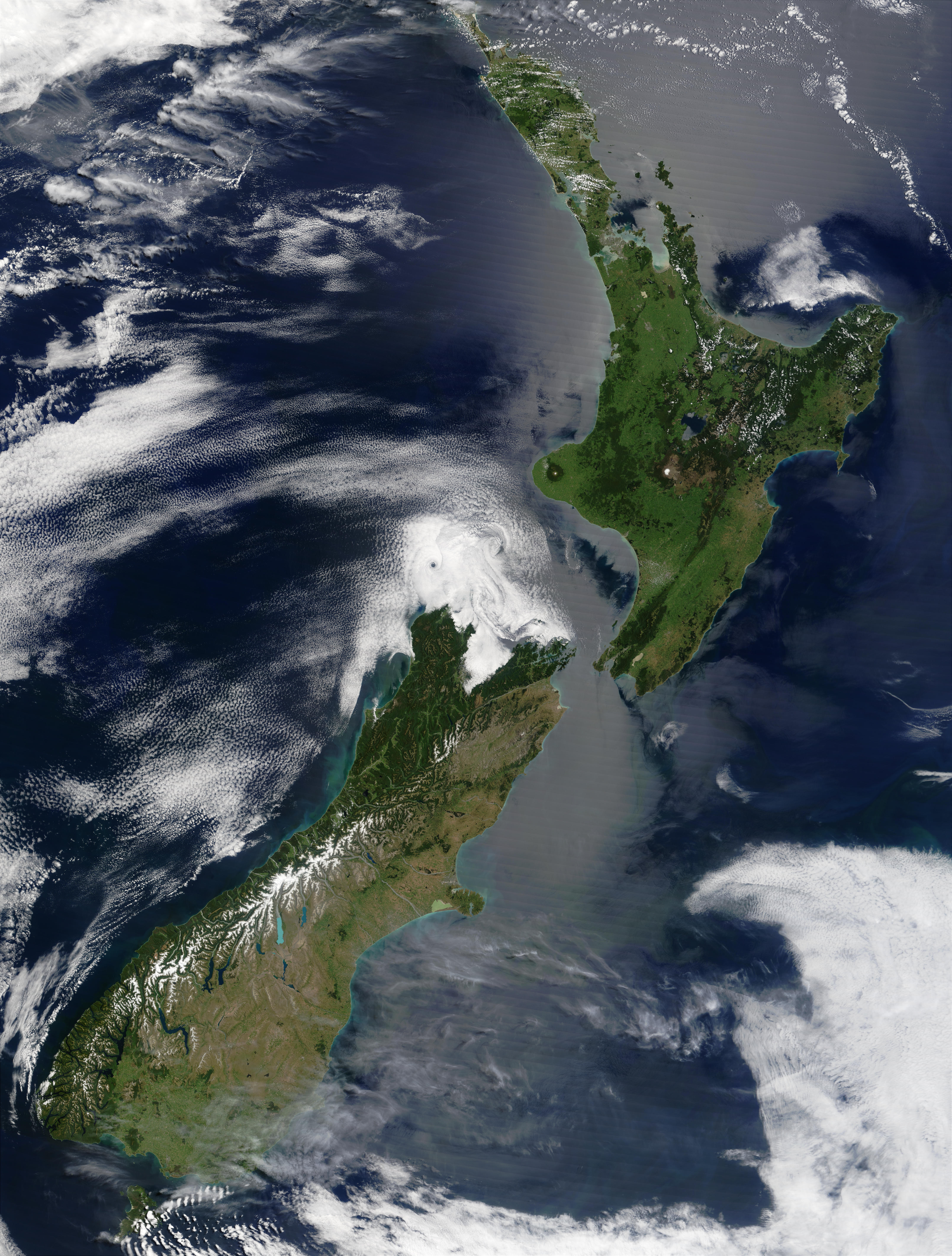
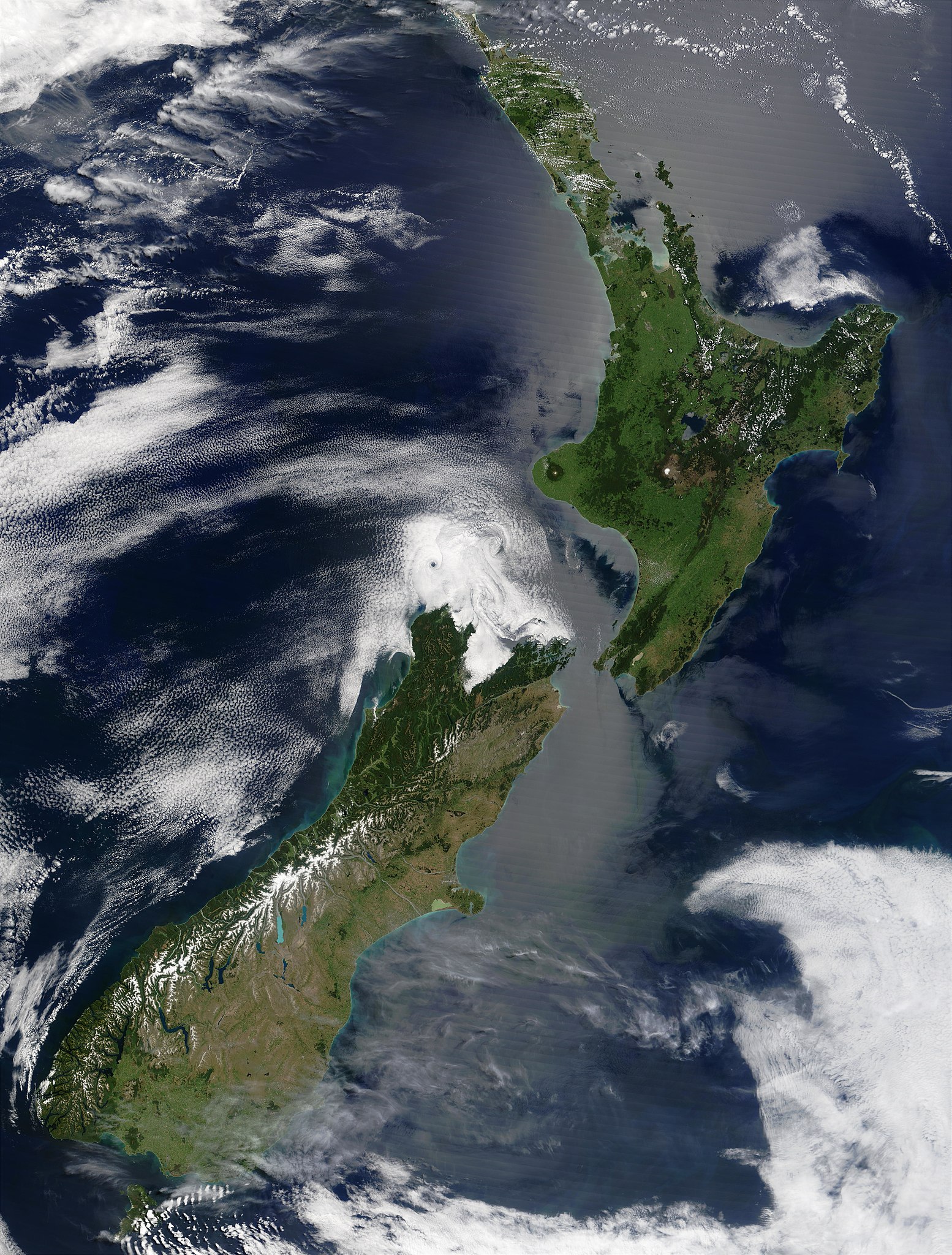
English: Satellite image of New Zealand in December 2002. NASA's description:
|
| 日付 | |
| 原典 | Taken from NASA's Visible Earth: [1] |
| 作者 | Jacques Descloitres, MODIS Land Rapid Response Team at NASA GSFC |
この画像は2005年9月12日の今日の一枚に選ばれました。その際の説明文は以下のとおりでした。 日本語: 2002年12月のニュージーランドの衛星写真 他の言語
Brezhoneg : Skeudenn dre loarell eus Zeland-Nevez e Kerzu 2002. Čeština: Satelitní snímek Nového Zélandu z prosince 2002 Cymraeg: Delwedd lloeren o Seland Newydd, yn Rhagfyr 2002. Dansk: Satellitbillede af New Zealand fra december 2002. Deutsch: Satellitenbild von Neuseeland in Dezember 2002 English: Satellite image of New Zealand in December 2002. Español: Imagen de satélite de Nueva Zelanda en diciembre de 2002 Français : La Nouvelle-Zélande en décembre 2002, vue de l'espace Galego: Imaxe de satélite de Nova Zelanda en decembro de 2002. Latina: Photographema satellitium Novae Zelandiae, Decembre 2002 Nederlands: Satelliet foto van Nieuw-Zeeland in december 2002. Norsk nynorsk: Satelittbilde av New Zealand frå desember 2002. Polski: Satelitarny obraz Nowej Zelandii w grudniu 2002 Português: Imagem satélite da Nova Zelândia em Dezembro de 2002. Slovenčina: Satelitný záber na Nový Zéland z decembra 2002 Suomi: Uusi Seelanti satelliittikuvassa joulukuussa 2002. Русский: Спутниковый снимок Новой Зеландии в декабре 2002. ไทย: ภาพถ่ายดาวเทียมประเทศนิวซีแลนด์เมื่อเดือนธันวาคม พ.ศ. ๒๕๔๕ 日本語: 2002年12月のニュージーランドの衛星写真 |
| このファイルはアメリカ航空宇宙局(NASA)によって作成されたものです。NASAの著作権の方針では、特記事項が無い場合、NASAの資料はパブリックドメインとなります。 (詳しくはTemplate:PD-USGov、NASAの著作権の方針について(英語)又はジェット推進研究所(JPL)の画像使用に関するガイドライン(英語)をご覧ください。) |
||
 |
注意事項:
|
ファイルの履歴
過去の版のファイルを表示するには、その版の日時をクリックしてください。
| 日付と時刻 | サムネイル | 寸法 | 利用者 | コメント | |
|---|---|---|---|---|---|
| 現在の版 | 2005年5月3日 (火) 15:51 | | 4,400 × 5,800 (3.39メガバイト) | Hautala | {{PD-USGov-NASA}} Satellite image of New Zealand in December 2002. NASA's description: :These stunning true-color images provide a rare, cloud-free look at the island nation of New Zealand, including most of its North and South Islands. This scene was ac |
ファイルの使用状況
以下のページがこのファイルを使用しています:
グローバルなファイル使用状況
以下に挙げる他のウィキがこの画像を使っています:
- ckb.wikipedia.org での使用状況
- en.wikipedia.org での使用状況
- eo.wikipedia.org での使用状況
- es.wikipedia.org での使用状況
- frp.wikipedia.org での使用状況
- fr.wikipedia.org での使用状況
- got.wikipedia.org での使用状況
- hu.wikipedia.org での使用状況
- hy.wikipedia.org での使用状況
- ia.wikipedia.org での使用状況
- is.wikipedia.org での使用状況
- ja.wikipedia.org での使用状況
- ka.wikipedia.org での使用状況
- ko.wikipedia.org での使用状況
- nl.wikipedia.org での使用状況
- pl.wikipedia.org での使用状況
- pt.wikipedia.org での使用状況
- ru.wikipedia.org での使用状況
- ru.wikinews.org での使用状況
- sl.wikipedia.org での使用状況
- sw.wikipedia.org での使用状況
- ta.wikinews.org での使用状況
- tr.wikipedia.org での使用状況
- vi.wikipedia.org での使用状況
- zh.wikipedia.org での使用状況